Taung
Taung 40 km north of Jan Kempdorp is a sprawling town that doesn't seem to hold much interest for me. Checking on Google Earth the geo-location of what I think is about the centre of town: 27.5314°S, 24.7853°E, and 1091m above sea level.
It is not a new town, Emil Holup during his travels in 1872-74 passed through it.
The main reason why I wanted to visit the place was because of the Taung child, a fossil of an early proto human that has been found there. The area around the spot where the fossil had been found is now a World Heritage Site, accessible to the public through a security gate, no fees charged.
Emil Holub was here
There is a bit of history in his book Ref 2. Ihave translated the relevant section from the original German, it's actually a combined effort of Google and myself. Here it is:
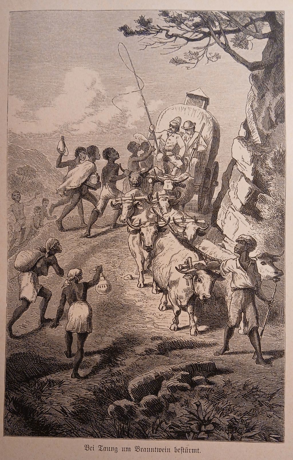 Among the Batlapin towns, Taung undisputedly occupies the first place, partly because of its picturesque location on one of the main transport routes to the interior, and partly because of its population. Unfortunately, its welfare had declined from year to year and I believe that Taung is probably now , after the export of spirits to Mankuruana's Land was made as difficult as possible by the government in Griqualand-West, will rise again and namely grain, livestock, etc.export to diamond fields, which will greatly benefit from its relatively short distance from this market; In addition, due to its location near the Hart River, the city has the opportunity to irrigate the cultivated lowlands regularly and efficiently. The previous population of Taung can be given as 5-6000, the current population (1879) as 3500-4000. The number varies around 500 because some families periodically go away to their cattle posts where their servants look after the cattle, the men often go out hunting in large numbers and others bring their Makalahari servants with them.
Around the time of my visit and three years later (1877) there were bad times for Taung, which were partly caused by the excitement during the battles against the vassal chief Mora and against Gassibone, and partly by great drought and its consequences that were felt everywhere. In 1872 several families in Taung died of starvation because they sacrificed everything, even the last fur on which they lay, the wood from the roofs of their huts, to the brandy sellers.
In 1843 the London Missionary Station was opened at Taung by Mr.Roß. However, King Mahura (the uncle of Mankuruana) left the city to settle on the heights of Mount Mamusa (two days' journey upstream), whither, according to the information of my esteemed friend, Rev. S. Mackenzie of Kuruman, he was succeeded by the white preacher, and there also remained when Wahura thought again a few years later to make Taung his residence. Mr. Roß had built churches in both places, which have since fallen into ruins, and then set up his headquarters in Lekatlong, mentioned on the first trip. In 1858 the scene of a cruel battle took place in Taung, the victims of which we can still be found as pale bones in the rocky clefts overlooking the heights of Taung. The fate of the Mahuras-Batlapins was all the harder because they were innocently involved in this war, which ended with the battle in Taung.
The old, dilapidated church had been replaced by a new one, not unlike one of our usual rural workers' cottages, in fact, apart from the mission house, it was the only building in the European style and was viewed with no small amount of pride by the local community. Nearby there was a small bell hanging in a planted tree fork, the sound of which was enough to call the small community to gather.
Among the Batlapin towns, Taung undisputedly occupies the first place, partly because of its picturesque location on one of the main transport routes to the interior, and partly because of its population. Unfortunately, its welfare had declined from year to year and I believe that Taung is probably now , after the export of spirits to Mankuruana's Land was made as difficult as possible by the government in Griqualand-West, will rise again and namely grain, livestock, etc.export to diamond fields, which will greatly benefit from its relatively short distance from this market; In addition, due to its location near the Hart River, the city has the opportunity to irrigate the cultivated lowlands regularly and efficiently. The previous population of Taung can be given as 5-6000, the current population (1879) as 3500-4000. The number varies around 500 because some families periodically go away to their cattle posts where their servants look after the cattle, the men often go out hunting in large numbers and others bring their Makalahari servants with them.
Around the time of my visit and three years later (1877) there were bad times for Taung, which were partly caused by the excitement during the battles against the vassal chief Mora and against Gassibone, and partly by great drought and its consequences that were felt everywhere. In 1872 several families in Taung died of starvation because they sacrificed everything, even the last fur on which they lay, the wood from the roofs of their huts, to the brandy sellers.
In 1843 the London Missionary Station was opened at Taung by Mr.Roß. However, King Mahura (the uncle of Mankuruana) left the city to settle on the heights of Mount Mamusa (two days' journey upstream), whither, according to the information of my esteemed friend, Rev. S. Mackenzie of Kuruman, he was succeeded by the white preacher, and there also remained when Wahura thought again a few years later to make Taung his residence. Mr. Roß had built churches in both places, which have since fallen into ruins, and then set up his headquarters in Lekatlong, mentioned on the first trip. In 1858 the scene of a cruel battle took place in Taung, the victims of which we can still be found as pale bones in the rocky clefts overlooking the heights of Taung. The fate of the Mahuras-Batlapins was all the harder because they were innocently involved in this war, which ended with the battle in Taung.
The old, dilapidated church had been replaced by a new one, not unlike one of our usual rural workers' cottages, in fact, apart from the mission house, it was the only building in the European style and was viewed with no small amount of pride by the local community. Nearby there was a small bell hanging in a planted tree fork, the sound of which was enough to call the small community to gather.
Taung World heritage site
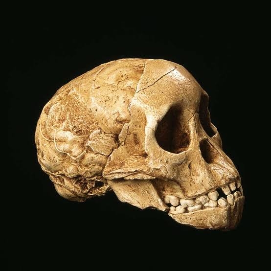
 It was here that first fossil identified as Australopithecus africanus was found in 1924. That was in the Buxton lime quarry, limestone was quarried here. During that process they found a number of fossilised bones of animals. The one that drew their attention was half a head (face) that looked out of place. It was handed to Professor Raymond Dart of the Wits University, who got to work on it and classified it as a new species, somewhere between apes and humans, i.e. a missing link. This, of course, was very controversial at the time. Opinions changed when bones of the same species were found at other sites, Sterkfontein, Makapansgat and East Africa.
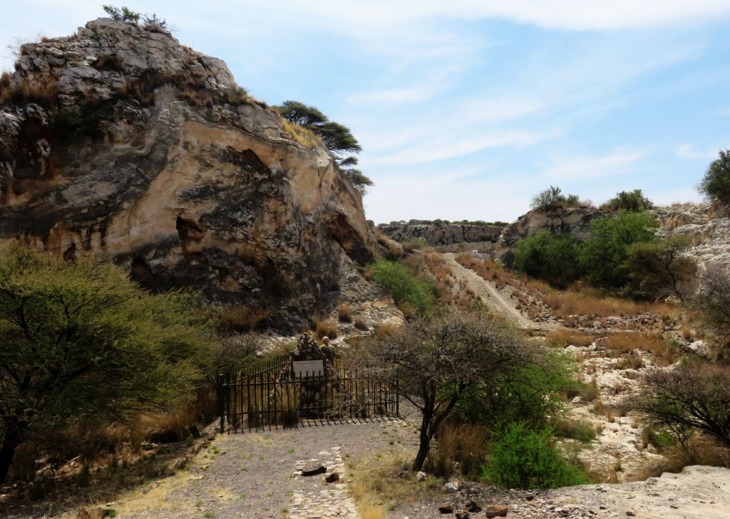
 A cairn and Information board were erected at the spot where the skull had been found. Unfortunately, the information board has weathered away and there is no information.
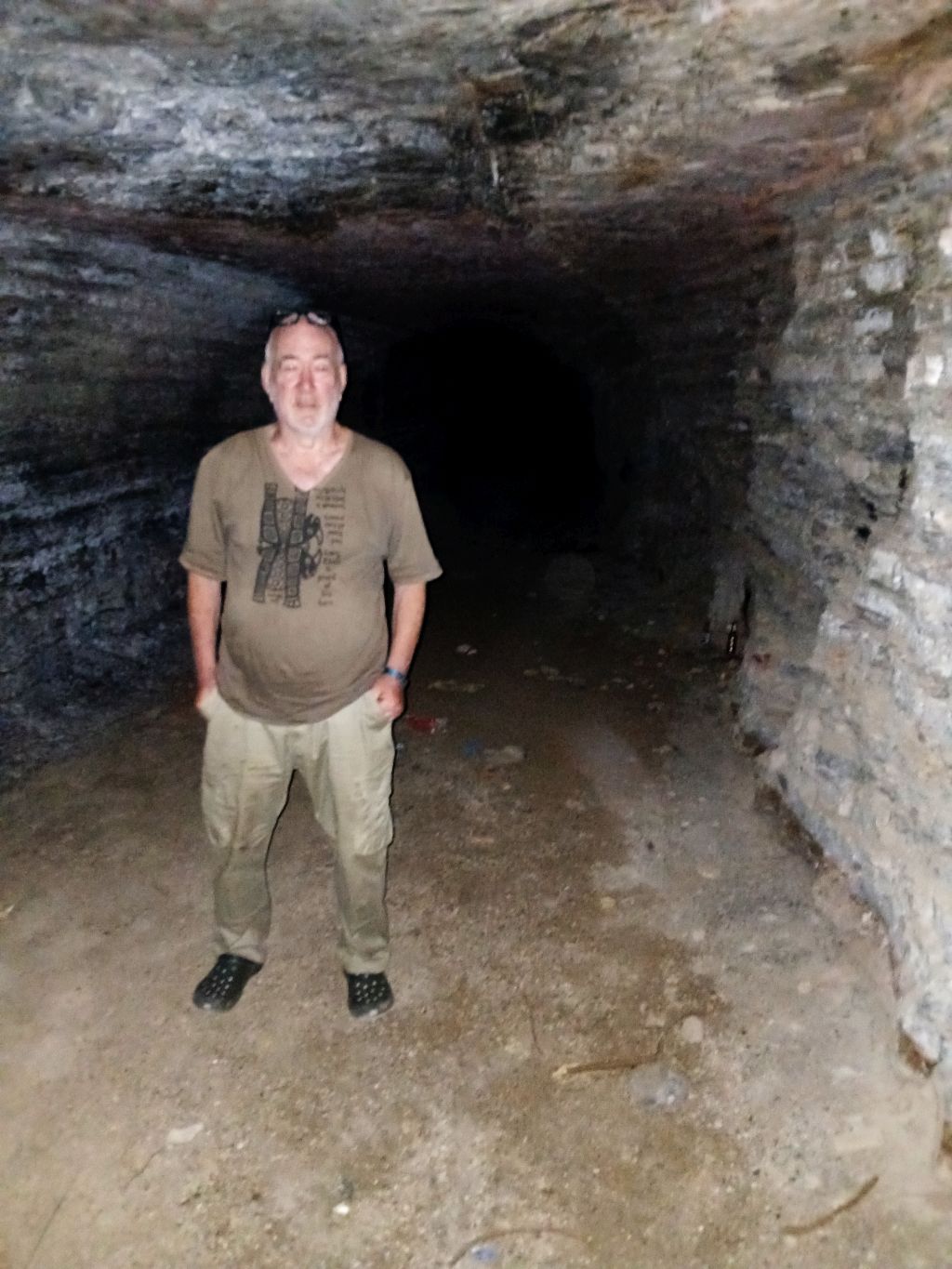
Driving around, it is obvious that at one time lots of money was spent on it. The road of interlocking paving is in good condition, at the furthest point on the road is a camp and ablution building that looks pretty new, but all locked up. Near that point is also a tunnel through the mountain. I am not sure for what purpose this was hacked through the mountain. It is blocked off with a grid, a few missing bars allowed me, as an ex-caver, easy entry. The internet talks about some blue pools, which would require some walking to get to.
It looks like an interesting place to do some hiking in. A possible problem is that the terrain could be a bit too rough for my ancient bones.
Norlim Catholique church
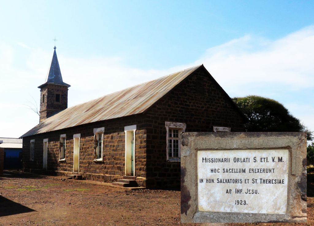 That was a chance find, coming back from the quarry I noticed a spire sticking out from the surrounding. Lets have a look. So we did. It turned out to be a church built by catholic missionaries. Google had a difficult task translating the inscription, what it came up with is: Missionaries offered ....They erected this chapel in honour of the saviour and St Theresa by .... Jesus. 1923. So we know it was constructed in 1923.
It is standing empty now, but is is not dilapidated. It is kept clean and it looks like still being used on occasion. There is a newer building next to it which, I assume, is being used as a church now.
References
Ref 1.: Standard Encyclopedia of Southern Africa, Nasou Limited, 1974
Ref 2.: Emil Holub "Sieben Jahre in Süd-Afrika", subtitle: "Erlebnisse, Forschungen und Jagden auf meinen Reisen von den Diamantenfeldern zum Zambesi (1872-1879)", printed Wien 1881.