Venterskroon
One would call it a hamlet, it's got a few houses and it has history. Situated in the rim of the Vredefort Dome next to the Vaal river at 26.8873°, 27.2683°E and 1349m amsl
History in general
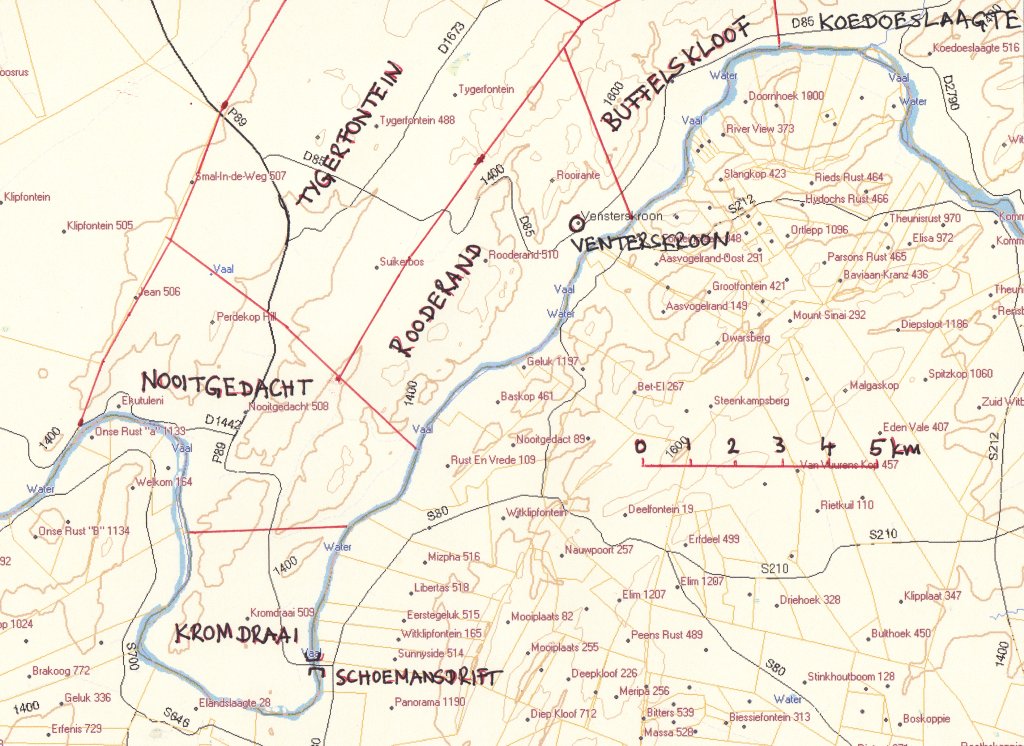 When studying the history of the place it gets very confusing if one is not familiar with the names of the original farms. I have thus prepared this little map of the area showing the names of the farms.
Venterskroon was going to be a town, but then they ran out of gold. It was to be a mining town, after gold was discovered in the area. It is the same gold as on the Witwatersrand, exposed and pushed to the surface by the meteorite that struck the area about 2 Billion years ago. And that is also the reason why the gold ran out. The force of the impact brought up the gold seams but also scattered them. Mining was a bit of a hit and miss, now you have it, now you don't.
The sniff of gold had been around for some time. In 1869 Rooderand, the farm where Venterskroon was later established, was declared a public digging and the Potchefstroom Exploration Syndicate started mining on the farm Kromdraai 1882. This is the farm bordered by the loop of the Vaal at Schoemansdrift.
Officially the town started 1887 in the middle of the a gold fever, it was hoped at the time that it would become bigger than Johannesburg.
Gold mines
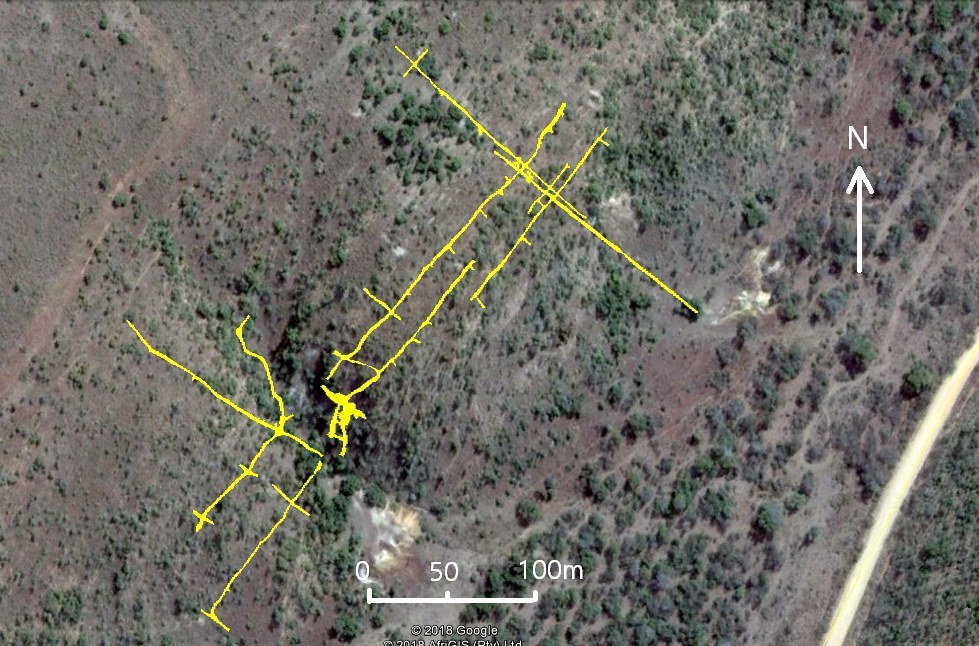 Despite all the gold fever there were relatively few mines that actually got into sustainable production. I have already mentioned the Great Western on
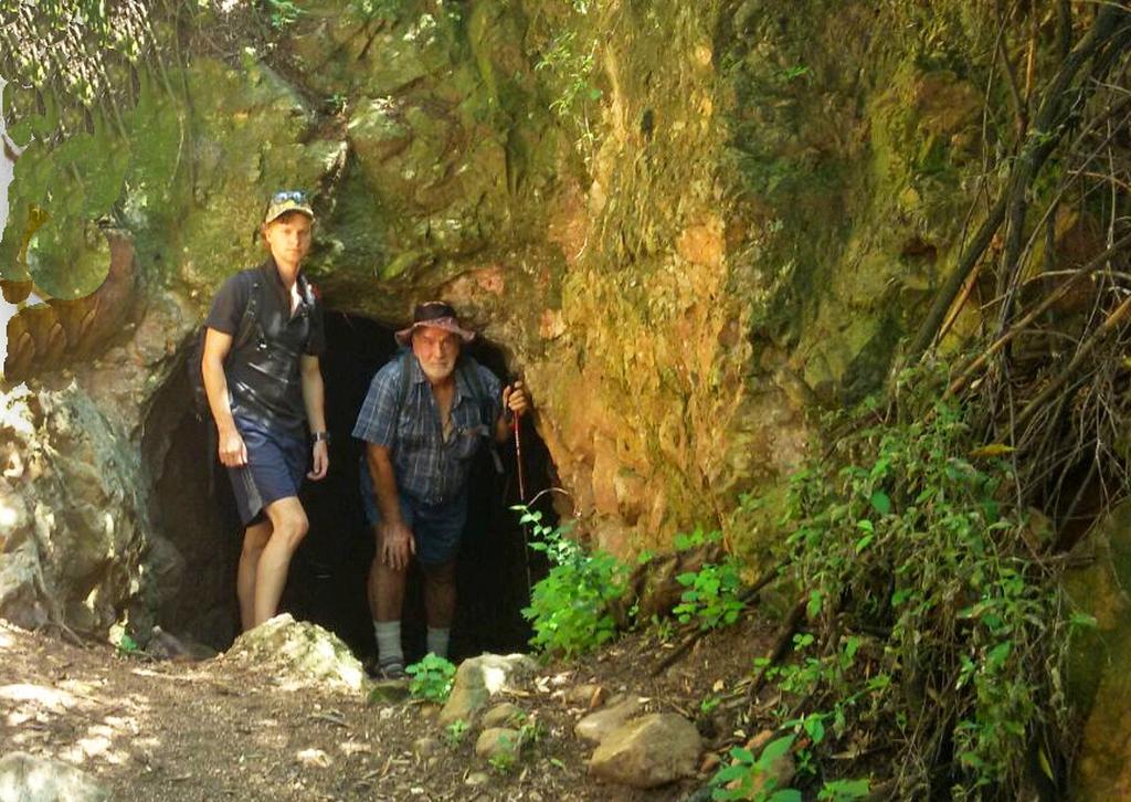
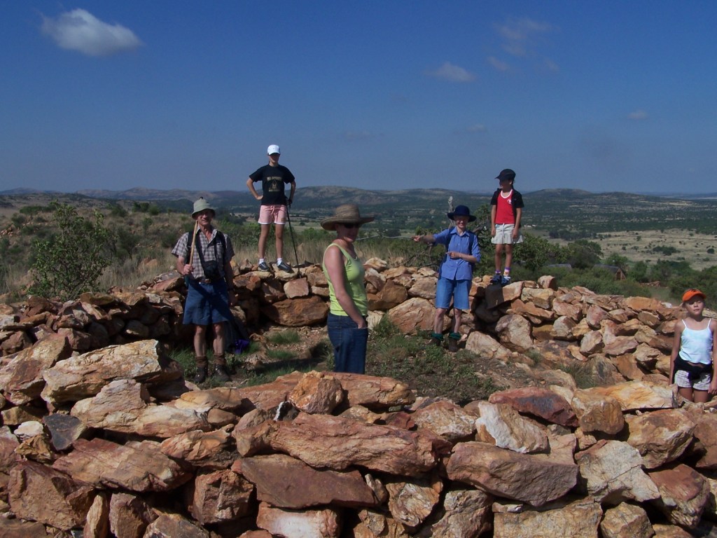
the Free State side of the river when I covered Reitzburg. On this side I only know of Luiperdsmine, the size of its mine dump is substantial. It is on the farm Rooderand 510 IQ. Nowhere in the references have I found the name Luiperdsmine, I use the name because some years ago, as a younger caver exploring the adits and shafts we came across this name inscribed at one of the entrances. The network of adits is fairly extensive. The survey done by the Cave Exploration Group has been superimposed onto a Google Earth image.
Despite all the gold fever there were relatively few mines that actually got into sustainable production. I have already mentioned the Great Western on
the Free State side of the river when I covered Reitzburg. On this side I only know of Luiperdsmine, the size of its mine dump is substantial. It is on the farm Rooderand 510 IQ. Nowhere in the references have I found the name Luiperdsmine, I use the name because some years ago, as a younger caver exploring the adits and shafts we came across this name inscribed at one of the entrances. The network of adits is fairly extensive. The survey done by the Cave Exploration Group has been superimposed onto a Google Earth image.
The surface infrastructure is fairly extensive, indicating profitable mining activity for a number of years. How long, I don't know. Johann van der Merwe ✝ at Thabela Thabeng told us that the mine operated until 1953.
 At Thabela Thabeng, Buffelskloof, are two excavations leading into the mountain. That mine must have started with a fair bit of optimism. There are signs of a road from the mine to an area of two ruined buildings, one of mud bricks and the other one of rocks. But there are no signs of reduction works. I would have expected to find at least some foundations for a crusher.
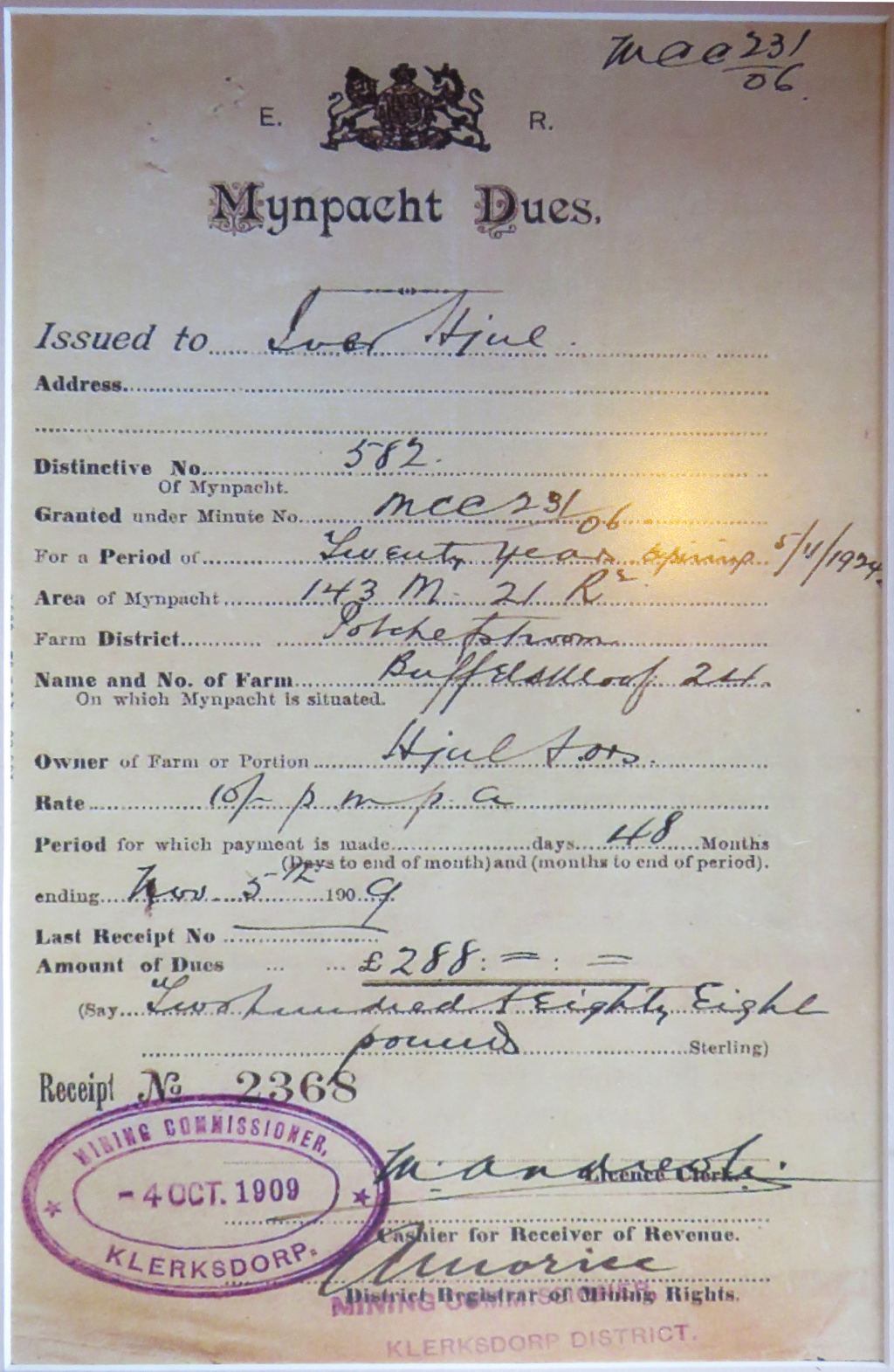
In the bar of the Imperial Inn is a framed Myne Pacht (mining lease) covering the farm Buffelskloof No.24. The lease was issued in 1909 and was valid for 20 years. Ref.1 deals in detail with this mynpacht. The document shown is actually a renewal, the original license was issued in 1891 to van Blummenstein & Hjul. Unfortunately from the documentation it is not obvious when mining activity actually took place. And what makes it more complicated is that the map in Ref.1 seems to indicate that the mine under discussion is not in the lease areas, but well on the farm Buffelskloof. Some more investigation is required here.
The document introduces an interesting character of the area, Ivor Hjul. Born 1-May-1844 in Halk, a little village near Haderslev in Denmark. To me he was an
amazing person, wandered the world in search of gold and diamonds. He lived in Australia in 1866, in New Zealand from 1868 to 1874, in Pilgrims rest 1874,
Kimberley 1881, Jagersfontein and then to Potchefstroom in 1888 where he had a mill. Apart from milling maize he got involved in prospecting, apart from the
lease at Buffelskloof, he is also mentioned as a claim holder at Rooderand in 1903.
It is claimed that he had minimal education and could not read or write, but he could sign his name. On one of his signatures I can see his full name was
Iver Hansen Hjül, note the the two dots on the u. Isn't that amazing? Illiterate and becoming a successful businessman. Just shows you, education isn't
everything.
original buildings
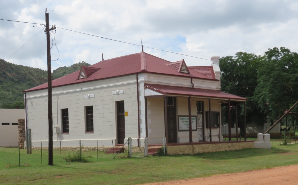
 A few buildings of the original town are still standing. The building on the left served
as a school and a police station, the cells are still at the back. The inscription over the main door states that it was erected in 1889.
A few buildings of the original town are still standing. The building on the left served
as a school and a police station, the cells are still at the back. The inscription over the main door states that it was erected in 1889.
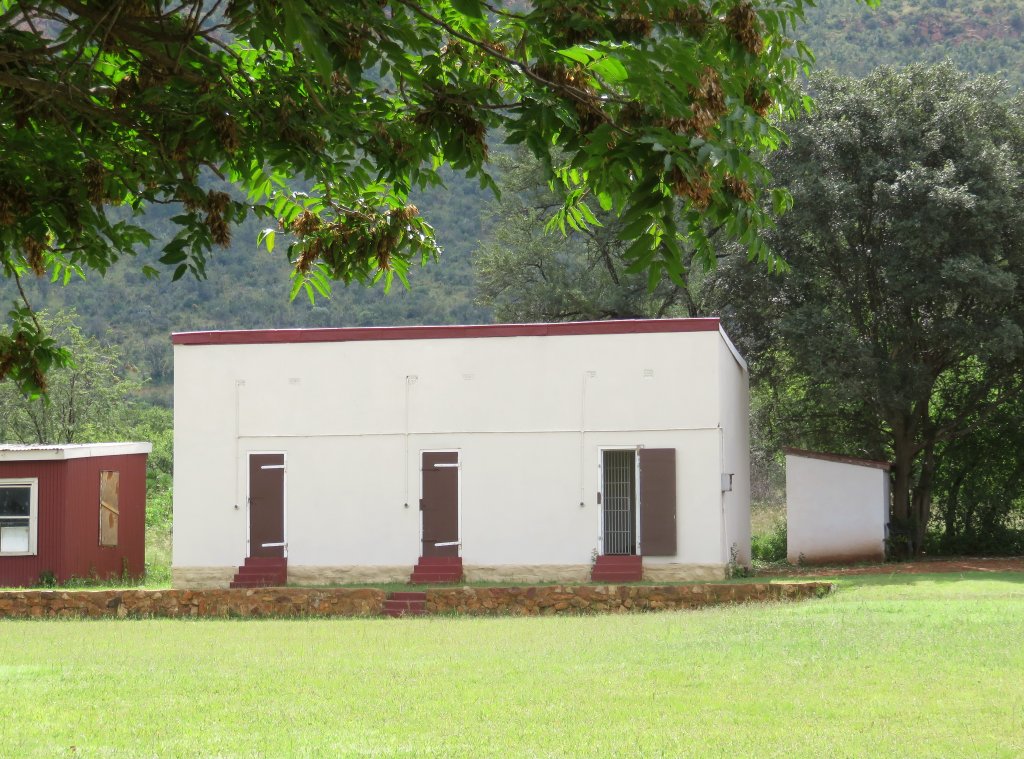
Other buildings are the school masters house and the mining commissioners office. The police station is now the museum, the mining commissioners house is
rented out to a painter temporarily and the school masters house can be rented for overnight stays. That was the situation in March 2017. The whole village
is actually up for sale at an asking price of R4.5 Million.
 Further up the road, toward
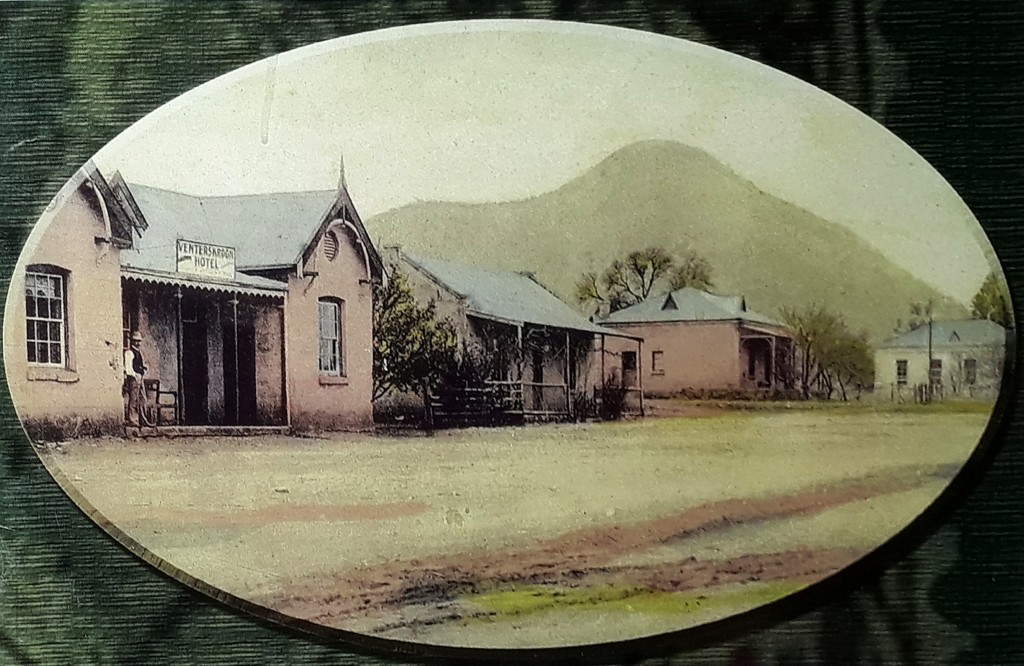
the west, is the Imperial Inn. The building is believed to also go back to 1889, or at least around that time. The old photo hanging in the bar not only
shows the hotel, in those days called the Venterskroon Hotel, further back is the mining commissioners house and at the end the police station and magistrate.
The house next to the hotel is no more.
Further up the road, toward
the west, is the Imperial Inn. The building is believed to also go back to 1889, or at least around that time. The old photo hanging in the bar not only
shows the hotel, in those days called the Venterskroon Hotel, further back is the mining commissioners house and at the end the police station and magistrate.
The house next to the hotel is no more.
Thabela Thabeng
Thabela Thabeng is not the name of the farm as such, on the net it's called a mountain retreat, with magnificent chalets and rooms to let. The farm is a
portion of Buffelskloof, for reference purposes I will call the farm Thabela Thabeng. And it has history.
It is on record (Ref.1) that a portion of Buffelskloof was sold to SG Schoeman in 1868. I have good reasons to think it was this portion, Thabela Thabeng.
Some years ago during one of our visits Johann said to me, 'look what I have found' and showed me a grave stone in his museum. I could decipher the name
Schoeman. He never told me where he had found it, it was at the time when he was planting Macadamia trees and I presume the stone surfaced when he was preparing
the land for planting. .
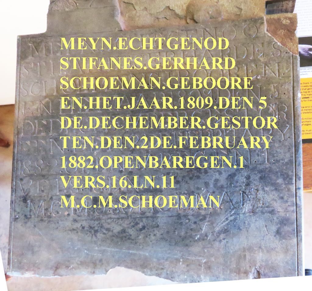 Let's have a look at this stone, here is what it says:
My husband
Stifanus Gerhard
Schoeman born
in the year 1809 the 5.
December died
on the 2nd February
1882 Revelations 1
verse 16 line 11
M.C.M.Schoeman
Just for interest, I looked up Revelations in my Bible, International edition, it says: 'and cursed the God of heaven because of their pains and their sores,
but they refused to repent of what they had done'. To make sure I am not wrong I also checked this in a Hollands Bible and in my German Bible, all very similar.
Either, I don't understand the meaning of this verse or it was a mistake. Surely this is not the sort of verse one puts on somebodies grave stone.
The stone has since been removed and replaced by an other, where it has been moved to I don't know.
But it was replaced by a different one and that one states that J(?)Scheepers born 9 July 1875 died 18 Nov 98 is buried here. The name Scheepers does come up
as one of the early occupiers of the farm.
Higher up under Gold Mines I mentioned the mine shafts on this farm. It must have been a serious operation because a road was constructed up to the shafts. The
road bed is still clearly visible near the mine. Further back toward the Venterskroon road a cutting had to be made to get the road through the narrow gorge.
This was the Gold Road as referred to by Albie, the present manager of TT. The road was used to transport the ore from the mines down to the reduction works. I
am not sure where that would have been.
When all that happened and whether Iver Hjul had something to do with that I am not sure. More probing is required.
The holiday houses were built by Johannes and Peggy van der Merwe, I think, in the 80th of the previous century.
Boer War
Battle of Tygerpoort
I am not sure one can call this a battle, de Wet in his book (ref 4) describes the 'battle' in three sentences. Be this as it may, what happened was that de Wet and his forces crossed the Vaal at Schoemansdrift on the 6 of August 1900 to escape the British encirclement from the south. From the drift he turned right to be between the river and the mountain to get to Venterskroon and past it. His aim was van Vuurens kloof, where he planned to set up camp.
His scouts informed him that the British had arrived at Tygerfontein and could thus threaten the movement of the Boers. He sent out a force to hold them off for a while until he had made good his escape through van Vuurens kloof. It resulted in some lively exchange of fire, including that of cannons from both sides.
And what was going on with the British side.Lord Kitchener had ordered General Methuen to move from Potchefstroom to Skandinaviersdrift, to cross the drift and to move east along the river to get to de Wets position on the south side of Schoemansdrift. This was when the Boers crossed into the Transvaal at Schoemansdrift. When Kitchener became aware of this he ordered General Methuen to stay on the north side of the river and to make his way toward Schoemansdrift. Thinking that de Wet was going to make his way to Potchefstroom. And all this at very short notice, there was no time to even have lunch, they had to keep on marching. There were no roads that could be used which made progress very difficult. By late after noon Tygerfontein was reached and they had to spent the night without food and without blankets, because the supply could not keep up with them.
De Wet succeeded in holding off the British, but he got a surprise the next morning when he was attacked in his camp at van Vuurens kloof. The enemy had succeeded to get to his camp unnoticed by de Wets scouts. It resulted in an exchange of fire and a hasty retreat by de Wet toward the Gatsrand mountains to the north.
Elswick Battery
 On the farm Tygerfontein to the west of
the road to Potchefstroom are the remains of some fortifications going back to the Boer War. One of them is marked as the position of one of the guns of the
Elswick Battery, that was by no means the only position, but the one that is marked.
On the farm Tygerfontein to the west of
the road to Potchefstroom are the remains of some fortifications going back to the Boer War. One of them is marked as the position of one of the guns of the
Elswick Battery, that was by no means the only position, but the one that is marked.
The canons used here were 12 pounders of the Elswick battery, they were 5 inch and their reach was up to 10000 yards, much further than most guns used by
the British forces. There is a bit more of a story to it. The canons were ordered and paid for by Lady Meux, a wealthy and eccentric heiress to a brewing
house. She presented these guns to Lord Roberts, the commander in chief of the forces in South Africa. They were to be used in the war effort, but were
actually the private property of the Lord. The full story can be read in the website of the Military History Journal.
 Also on the farm Tygerfontein was a heliograph station on the peak of one of the mountains, see picture.
Cemetery
Should I rather say, the search for the cemetery. We found a fair sized cemetery on the farm Koedoeslaagte about 8 km from Venterskroon. That one has been captured on the eGGSA website. It is too far out of town to be the Venterskroon cemetery and surely there must have been one. Still we had a look at it.
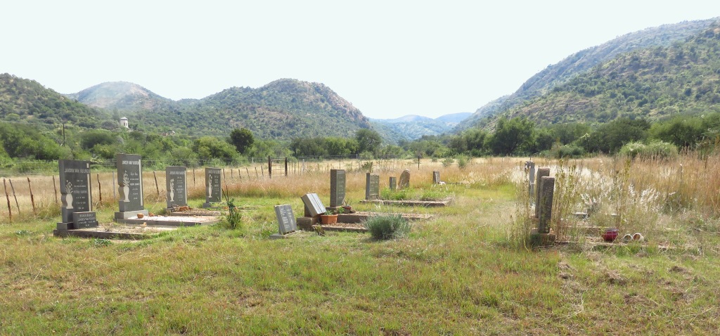 A fair sized cemetery of about 100 graves, the oldest I spotted was from 1911. And the most common name was van Vuuren, not surprising since the valley going out to wards the Parys Potchefstroom road is named van Vuurens Kloof. Van Vuuren must have been one of the early settlers.
Thus the search for the Venterskroon cemetery has to continue. Actually it doesn't, because we know what happened. By two independent sources we were told that the grave yard used to be on the road out of Venterskroon just beyond the General Dealer. At some time (and apparently that wasn't that long ago) the owner of the farm flattened the graves and covered it with soil. The least one can say, disrespect for the dead.
Schoemansdrift
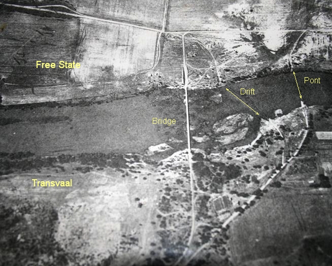
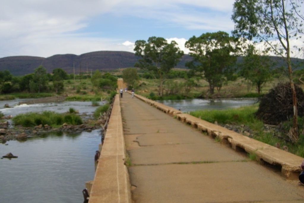 The drift was the crossing point when traveling between Kroonstad and Potchefstroom. It was the drift used by Gen de Wet for his first crossing into the Transvaal, see the story above. When the bridge was build, I am not sure, I guess in the 30th of the last century. I have been looking for a year mark on the bridge, not found anything.
An aerial photograph taken at around 1935 from ref 3 shows the bridge and the drift. The drift is the faint line downstream from the bridge. And what one can also see is where the pont/ferry was by following the still clearly visible old road. Going to Google Earth one can now hardly make out where the crossing points were, the road to the pont is totally gone, it has been ploughed over.
NH Church
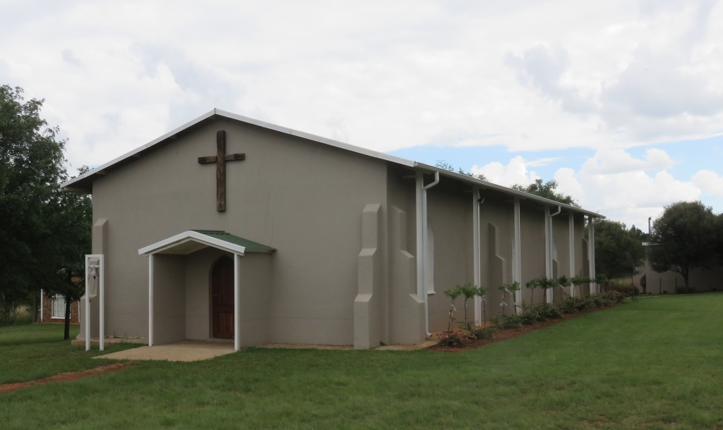 There is only one church in Venterskroon, it is a church of the Nederduitsch Hervormde Kerk (NH). From the records it sounds like there was no other church. The NH goes back to 1888 when the congregation was established. A church was built in 1889 and inaugurated by Ds.Goddefroy. The present church, according to the plague, was completed 1939, that is the church in the picture.
The location of the first church is not known, but I do have the suspicion that the new church was at least modelled on the old one. The style with the supporting buttresses and the shape of the windows reminds me of churches build in the 2nd half of the 19th century.
The church is not in regular use now, only for special occasions, i.e. weddings. The ground is available for camping and there are chalets for accommodation.
Delving into the history it is interesting to read that the congregation at Venterskroon was never large enough to support a full time preacher. From the beginning they had an agreement with other congregations to share a preacher. Early Ds.Lagerwey was shared between Klerksdorp, Volksrus, Heidelberg and Venterskroon. During 1908 when Ds.Ennis took up his post in Klerksdorp he was approached to also serve in Venterskroon. The agreement was that for a contribution of £60 they would have him for five Sundays a year. Ds.Venter started in 1930 and for £75 they got four holy communions, two Sundays and house visits. Ds.Venter was the one that inaugurated the new church in 1939.
Koedoeslaagte
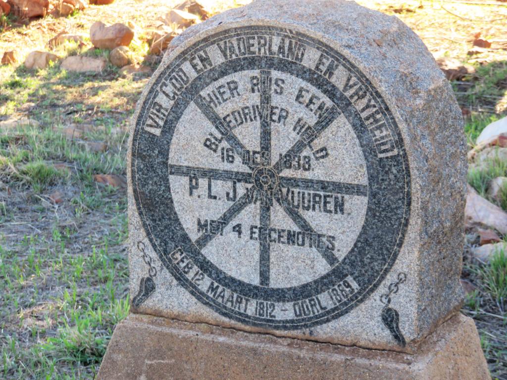
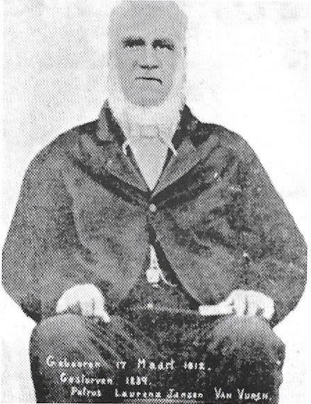 The farm Koedoeslaagte was first occupied by PLJ van Vuuren in 1840, this is also the farm where we find his grave. The grave stone reads, translated (semicolon indicates line break): For God And Fatherland and Freedom; here rests a; hero of; Bloodriver, 16 December 1838; PLJ van Vuuren; and 5 wives; born 12 March 1812 - died 1889 Additional information: his full name was Petrus Lourens Janse van Vuuren. he was
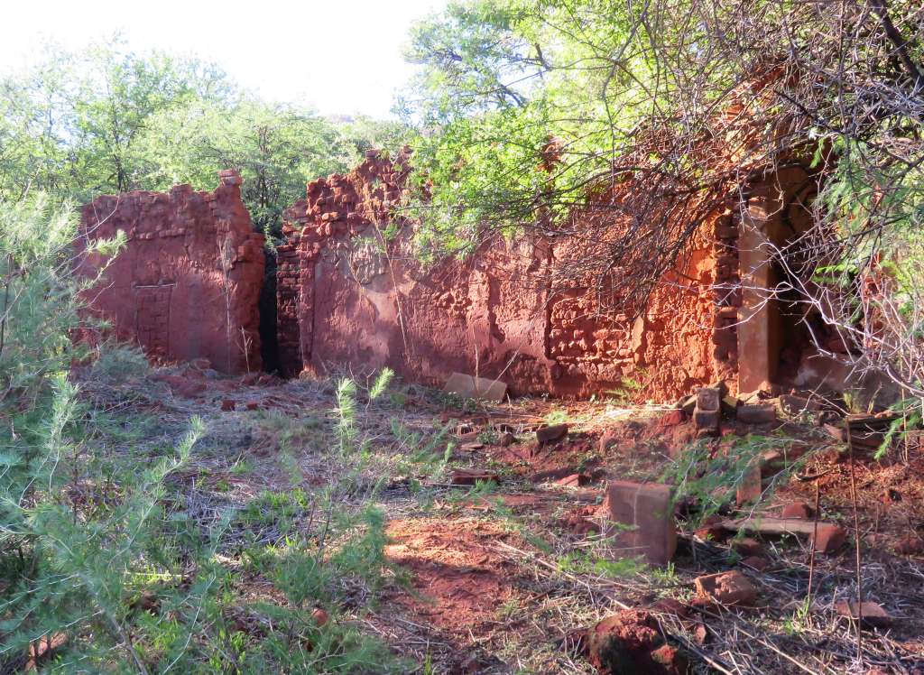 born at Graaff-Reinet and his date of death is given as 3 October 1889. And Bloodriver referes to the battle that took place between the Zulus and the Voortrekkers.
Near the little grave yard we also find the remnants of his house.
References
Ref 1.: Prof Okkie de Jager, Vredefort Dome from a Philatelic Perspective, 2005
Ref 2.: W.U.Reimold & R.L.Gibson "Meteorite Impact!", Springer Verlag, ISBM 978-3-642-10463-3
Ref 3.: J M Jansen van Rensburg, 'Geoconservation of abandoned goldmines and granite quarries in the Vredefort Dome World Heritage Site, South Africa'
Ref 4.: Chistiaan Rudolf de Wet, 'Three Years War', Charles Scribner's Sons, New York, 1902
Ref 5.: VE d'Assonville, 'Generaal De Wet in die Vredefortkoepel', Marnix Pretoria, 2010, ISBN: 978-0-620-46619-6
Ref 6.: Ds.S,J,Botha, Gemeente Klerksdorp 1866-1966, printed 1966 by N.H.W.-Pers Krugersdorp
Ref 7.: Nederduitsch Hervormde Kerk, 'Gemeente Venterskroon 1888*1988', author unknown